Pirep is a free, collaborative database of all public and private airports. All pilots are welcome to contribute their local knowledge to any airport, no registration required.

No upcoming events. Is anything happening here soon?
Last updated: 2024-06-24 22:48:18 PDT
Last updated: 2023-04-09 19:26:59 PDT
Airport Statistics
Location:
Olympia, WA
Elevation:
207ft
Sectional:
Seattle
Activation date:
Dec 1937
Fuel:
100LL, A (prices)
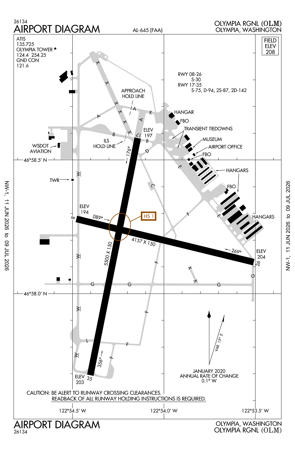
Runway 17/35:
5,500ft
Runway 08/26:
4,157ft
Access: Open to the public
Similar Airports
Current Weather — VFR
-
Weather data is strictly informational and not for flight planning purposes.
-
METAR2026-07-28 23:54:00 PDT
Ceiling: Sky clear Wind: 180° @ 3kt Temperature: 53°F Dewpoint: 50°F Weather: N/A Visbility: 10SM Raw:METAR KOLM 290654Z AUTO 18003KT 10SM CLR 12/10 A3007 RMK AO2 SLP182 T01220100 -
TAF2026-07-28 23:00:00 PDT – 2026-07-29 04:00:00 PDT
Ceiling: Sky clear Wind: 280° @ 4kt Weather: N/A Visbility: 6SM Clouds: Scattered @ 5,000ft Raw:TAF KOLM 290520Z 2906/3006 28004KT P6SM SCT050 FM291100 19004KT P6SM BKN020 FM291800 35005KT P6SM SCT025 FM292100 34007KT P6SM BKN250 FM300400 VRB04KT P6SM SKC -
TAF2026-07-29 04:00:00 PDT – 2026-07-29 11:00:00 PDT
Ceiling: 2,000ft Wind: 190° @ 4kt Weather: N/A Visbility: 6SM Clouds: Broken @ 2,000ft Raw:TAF KOLM 290520Z 2906/3006 28004KT P6SM SCT050 FM291100 19004KT P6SM BKN020 FM291800 35005KT P6SM SCT025 FM292100 34007KT P6SM BKN250 FM300400 VRB04KT P6SM SKC -
TAF2026-07-29 11:00:00 PDT – 2026-07-29 14:00:00 PDT
Ceiling: Sky clear Wind: 350° @ 5kt Weather: N/A Visbility: 6SM Clouds: Scattered @ 2,500ft Raw:TAF KOLM 290520Z 2906/3006 28004KT P6SM SCT050 FM291100 19004KT P6SM BKN020 FM291800 35005KT P6SM SCT025 FM292100 34007KT P6SM BKN250 FM300400 VRB04KT P6SM SKC -
TAF2026-07-29 14:00:00 PDT – 2026-07-29 21:00:00 PDT
Ceiling: 25,000ft Wind: 340° @ 7kt Weather: N/A Visbility: 6SM Clouds: Broken @ 25,000ft Raw:TAF KOLM 290520Z 2906/3006 28004KT P6SM SCT050 FM291100 19004KT P6SM BKN020 FM291800 35005KT P6SM SCT025 FM292100 34007KT P6SM BKN250 FM300400 VRB04KT P6SM SKC -
TAF2026-07-29 21:00:00 PDT – 2026-07-29 23:00:00 PDT
Ceiling: Sky clear Wind: Variable Weather: N/A Visbility: 6SM Clouds: @ ft Raw:TAF KOLM 290520Z 2906/3006 28004KT P6SM SCT050 FM291100 19004KT P6SM BKN020 FM291800 35005KT P6SM SCT025 FM292100 34007KT P6SM BKN250 FM300400 VRB04KT P6SM SKC
Click/tap to add an annotation marker to the map
Remarks
- Estabd prior to 15 may 1959.
- Twy lgts on twy w, a, l, and b.
- Airport field conditions unmonitored 1700 lcl - 0700 lcl.
- Emerg freq 121.5 not mnt at twr.
- For cd when atct is clsd ctc seattle apch at 206-214-4723.
Comments