Pirep is a free, collaborative database of all public and private airports. All pilots are welcome to contribute their local knowledge to any airport, no registration required.
No upcoming events. Is anything happening here soon?
Last updated: 2024-01-08 22:54:46 CST
Last updated: 2023-10-01 15:57:06 CDT
Last updated: 2024-01-08 22:56:27 CST
Airport Statistics
- Webcam links
- Transient parking location
- Landing & tie-down fees
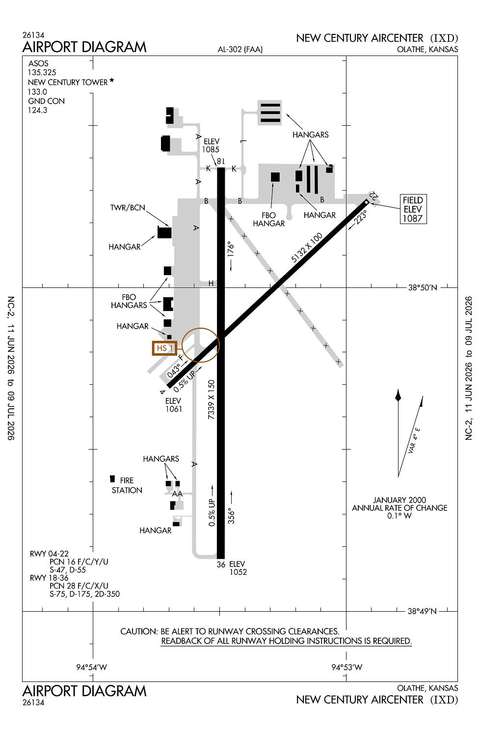
Location:
Olathe, KS
Elevation:
1,087ft
Sectional:
Kansas City
Fuel:
100LL, A (prices)
Runway 18/36:
7,339ft
Runway 04/22:
5,132ft
Access: Open to the public
Similar Airports

Current Weather — VFR
-
Weather data is strictly informational and not for flight planning purposes.
-
METAR2026-07-28 22:53:00 CDT
Ceiling: Sky clear Wind: Calm Temperature: 78°F Dewpoint: 75°F Weather: N/A Visbility: 10SM Clouds: Few @ 11,000ft Raw:METAR KIXD 290353Z AUTO 00000KT 10SM FEW110 26/24 A2991 RMK AO2 SLP115 T02560239 -
TAF2026-07-28 19:00:00 CDT – 2026-07-29 10:00:00 CDT
Ceiling: 10,000ft Wind: Variable Weather: N/A Visbility: 6SM Clouds: Broken @ 10,000ft Raw:TAF KIXD 282320Z 2900/2924 VRB05KT P6SM BKN100 PROB30 2909/2915 6SM -SHRA BKN050 FM291500 11009KT P6SM BKN120 -
TAF2026-07-29 04:00:00 CDT – 2026-07-29 10:00:00 CDT
Ceiling: 5,000ft Wind: 000° @ kt Weather: Light rain showers Visbility: 6SM Clouds: Broken @ 5,000ft Raw:TAF KIXD 282320Z 2900/2924 VRB05KT P6SM BKN100 PROB30 2909/2915 6SM -SHRA BKN050 FM291500 11009KT P6SM BKN120 -
TAF2026-07-29 10:00:00 CDT – 2026-07-29 19:00:00 CDT
Ceiling: 12,000ft Wind: 110° @ 9kt Weather: N/A Visbility: 6SM Clouds: Broken @ 12,000ft Raw:TAF KIXD 282320Z 2900/2924 VRB05KT P6SM BKN100 PROB30 2909/2915 6SM -SHRA BKN050 FM291500 11009KT P6SM BKN120
Click/tap to add an annotation marker to the map
No webcams added yet.
Remarks
- Avoid conflict gardner muni:ext unique pattern alt, rt tfc rwys 04/36, & restrict rwy 04/22 cat a acft.
- Birds & waterfowl on & invof arpt.
- Atct view of sw end of twy 'f' & rwy 04/22 is obscured.
- Low sun angles rdc vsby when xing rwy 18/36 fm twys 'a' or 'b'.
- Army ops: dsn 552-6994/5, c913-782-1077.
Comments