Pirep is a free, collaborative database of all public and private airports. All pilots are welcome to contribute their local knowledge to any airport, no registration required.

No upcoming events. Is anything happening here soon?
Last updated: 2024-02-10 04:21:56 EST
Airport Statistics
- Crew car availability
- General description
- Transient parking location
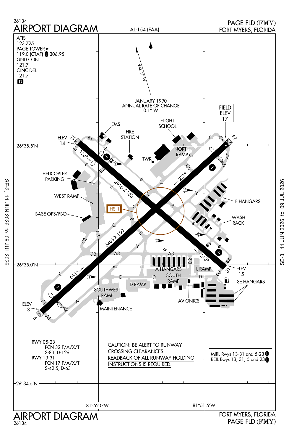
Location:
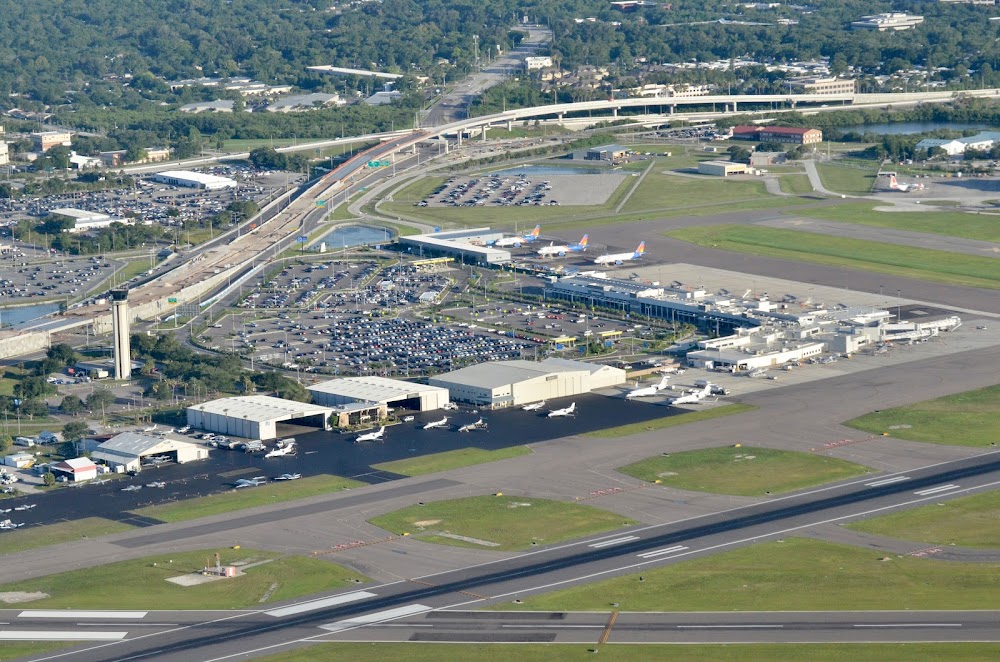
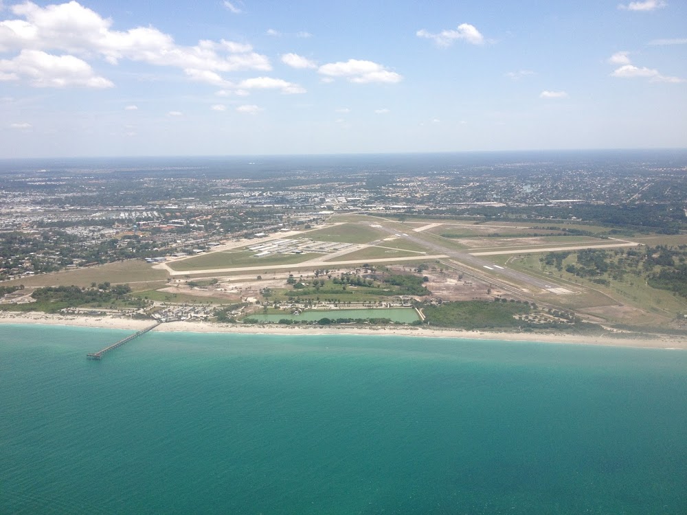
Fort Myers, FL
Elevation:
17ft
Sectional:
Miami
Activation date:
Apr 1940
Fuel:
100LL, A (prices)
Runway 05/23:
6,406ft
Runway 13/31:
4,910ft
Access: Open to the public
Similar Airports
Current Weather — VFR
-
Weather data is strictly informational and not for flight planning purposes.
-
METAR2026-07-29 05:53:00 EDT
Ceiling: Sky clear Wind: 250° @ 4kt Temperature: 80°F Dewpoint: 73°F Weather: N/A Visbility: 10SM Raw:METAR KFMY 290953Z AUTO 25004KT 10SM CLR 27/23 A2987 RMK AO2 SLP117 T02720233 -
TAF2026-07-29 02:00:00 EDT – 2026-07-29 11:00:00 EDT
Ceiling: Sky clear Wind: 240° @ 4kt Weather: N/A Visbility: 6SM Clouds: Scattered @ 25,000ft Raw:TAF KFMY 290523Z 2906/3006 24004KT P6SM SCT250 FM291500 25012G18KT P6SM VCTS SCT030CB SCT250 PROB30 2915/2919 VRB15G25KT 2SM TSRA BKN025CB FM292000 25013G20KT P6SM SCT040 BKN250 FM300100 24010KT P6SM SCT050 SCT250 -
TAF2026-07-29 11:00:00 EDT – 2026-07-29 15:00:00 EDT
Ceiling: 2,500ft Wind: Variable, gusts 25kt Weather: Thunderstorm rain Visbility: 2SM Clouds: Broken @ 2,500ft Raw:TAF KFMY 290523Z 2906/3006 24004KT P6SM SCT250 FM291500 25012G18KT P6SM VCTS SCT030CB SCT250 PROB30 2915/2919 VRB15G25KT 2SM TSRA BKN025CB FM292000 25013G20KT P6SM SCT040 BKN250 FM300100 24010KT P6SM SCT050 SCT250 -
TAF2026-07-29 11:00:00 EDT – 2026-07-29 16:00:00 EDT
Ceiling: Sky clear Wind: 250° @ 12kt, gusts 18kt Weather: Thunderstorm in vicinity Visbility: 6SM Clouds: Scattered @ 3,000ft, Scattered @ 25,000ft Raw:TAF KFMY 290523Z 2906/3006 24004KT P6SM SCT250 FM291500 25012G18KT P6SM VCTS SCT030CB SCT250 PROB30 2915/2919 VRB15G25KT 2SM TSRA BKN025CB FM292000 25013G20KT P6SM SCT040 BKN250 FM300100 24010KT P6SM SCT050 SCT250 -
TAF2026-07-29 16:00:00 EDT – 2026-07-29 21:00:00 EDT
Ceiling: 25,000ft Wind: 250° @ 13kt, gusts 20kt Weather: N/A Visbility: 6SM Clouds: Scattered @ 4,000ft, Broken @ 25,000ft Raw:TAF KFMY 290523Z 2906/3006 24004KT P6SM SCT250 FM291500 25012G18KT P6SM VCTS SCT030CB SCT250 PROB30 2915/2919 VRB15G25KT 2SM TSRA BKN025CB FM292000 25013G20KT P6SM SCT040 BKN250 FM300100 24010KT P6SM SCT050 SCT250 -
TAF2026-07-29 21:00:00 EDT – 2026-07-30 02:00:00 EDT
Ceiling: Sky clear Wind: 240° @ 10kt Weather: N/A Visbility: 6SM Clouds: Scattered @ 5,000ft, Scattered @ 25,000ft Raw:TAF KFMY 290523Z 2906/3006 24004KT P6SM SCT250 FM291500 25012G18KT P6SM VCTS SCT030CB SCT250 PROB30 2915/2919 VRB15G25KT 2SM TSRA BKN025CB FM292000 25013G20KT P6SM SCT040 BKN250 FM300100 24010KT P6SM SCT050 SCT250
Click/tap to add an annotation marker to the map
No webcams added yet.
Remarks
- High density bird population within the arpt boundaries.
- Brightly lgtd ball field 1500 ft se of aer 05.
- Noise sensitive airport - voluntary restriction for large aircraft and jet aircraft conducting multiple approaches and/or closed traffic.
- Twy 'b' se of twy 'a' is non-movement area not vsb fm atct.
- Paew adj to rys & twys during dalgt hrs.
Comments