Pirep is a free, collaborative database of all public and private airports. All pilots are welcome to contribute their local knowledge to any airport, no registration required.


No upcoming events. Is anything happening here soon?
Last updated: 2024-03-07 22:21:59 EST
Airport Statistics
- Fuel pump location
- Airport map annotations
- Crew car availability
Location:
Portsmouth, NH
Elevation:
100ft
Sectional:
New York
Activation date:
Jan 1946
Fuel:
100LL, A, J8 (prices)
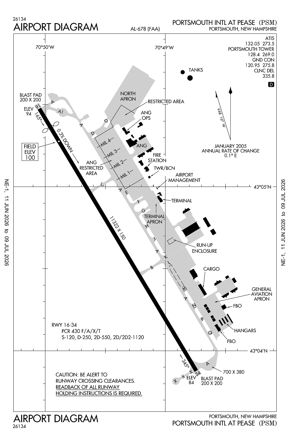
Runway 16/34:
11,322ft
Access: Open to the public
Similar Airports

Current Weather — MVFR
-
Weather data is strictly informational and not for flight planning purposes.
-
METAR2026-07-29 12:55:00 EDT
Ceiling: 2,800ft Wind: 070° @ 13kt Temperature: 68°F Dewpoint: 61°F Weather: Light rain Visbility: 10SM Clouds: Overcast @ 2,800ft Raw:METAR KPSM 291655Z 07013KT 10SM -RA OVC028 20/16 A2972 RMK AO2A RAB53 SLP066 P0000 T02040164 -
TAF2026-07-29 14:00:00 EDT – 2026-07-29 16:00:00 EDT
Ceiling: 1,500ft Wind: 090° @ 9kt, gusts 18kt Weather: Light rain, mist Visbility: 2SM Clouds: Overcast @ 1,500ft Raw:TAF KPSM 291720Z 2918/3018 09009G18KT 2SM -RA BR OVC015 FM292000 08012G20KT 2SM -RA BR OVC007 FM300300 05011G21KT 1 1/2SM -RA BR OVC003 -
TAF2026-07-29 16:00:00 EDT – 2026-07-29 23:00:00 EDT
Ceiling: 700ft Wind: 080° @ 12kt, gusts 20kt Weather: Light rain, mist Visbility: 2SM Clouds: Overcast @ 700ft Raw:TAF KPSM 291720Z 2918/3018 09009G18KT 2SM -RA BR OVC015 FM292000 08012G20KT 2SM -RA BR OVC007 FM300300 05011G21KT 1 1/2SM -RA BR OVC003 -
TAF2026-07-29 23:00:00 EDT – 2026-07-30 14:00:00 EDT
Ceiling: 300ft Wind: 050° @ 11kt, gusts 21kt Weather: Light rain, mist Visbility: 1SM Clouds: Overcast @ 300ft Raw:TAF KPSM 291720Z 2918/3018 09009G18KT 2SM -RA BR OVC015 FM292000 08012G20KT 2SM -RA BR OVC007 FM300300 05011G21KT 1 1/2SM -RA BR OVC003
Click/tap to add an annotation marker to the map
No webcams added yet.
Remarks
- Index e arff capability avbl 24/7.
- All inbd acft with hazus cargo info call atct 60 nm out.
- Turb apch end rwy 34 in strong x winds.
- No pla or tgl 2300-0700 for lcl-based acft, 2100-0700 for tsnt acft or bfr 1200 sun for all acft.
- Birds on and invof arpt.
Comments